Research and design for the FireClear project

Why a map?

Color choices, fonts, lines, symbols, etc. all come together and create a visual impression. Most traditional maps are heavy with detail and specific coding that take a level of skillset to read and understand. Most people do not use maps in their everyday life in order to effectively understand scientific, data-heavy, or dense maps. FireClear maps filter information to make information less dense, simplified, and more relevant to a non-trained person ranging in demographics and emergency experience. 

FireClear applies visual standards defined by visual grammar. This ensures that information is relevant and intentionally focused on the use and application of fire risk information for public use as well as supports a coherent, cohesive, and memorable information campaign.

Orange County

FireClear received the California Emergency Services Association’s Silver Award for the FireClear campaign in Laguna Beach, Orange County.

Disclaimer: Tsunami information and inundation area is reviewed and revised regularly by CalOES and CGS. The maps below do not reflect the most recent and updated changes. Please do not refer to these maps in an emergency situation. Refer to your local emergency management department in your city for updates.

Several brochures for the City of Laguna Beach, Orange County,  showing fire zones produced as part of FireClear's Visual standards for public-facing rick-literacy maps.

City area map for Laguna Beach North produced as part of FireClear's Visual standards for public-facing rick-literacy maps.

Brochure for Laguna Beach providing residents information on Defensible Space.

Brochure for Aliso Viejo, Orange County, showing fire zones produced as part of FireClear's Visual standards for public-facing rick-literacy maps.

Kiosk layout for Canyon View area in Aliso Viejo, Orange County, showing fire zones produced as part of FireClear's Visual standards for public-facing rick-literacy maps.

Brochure layout for the City of Irvine, Orange County, showing fire zones produced as part of FireClear's Visual standards for public-facing rick-literacy maps.

Brochure for Zone 21D in the City of Irvine, Orange County, showing fire zones produced as part of FireClear's Visual standards for public-facing rick-literacy maps.


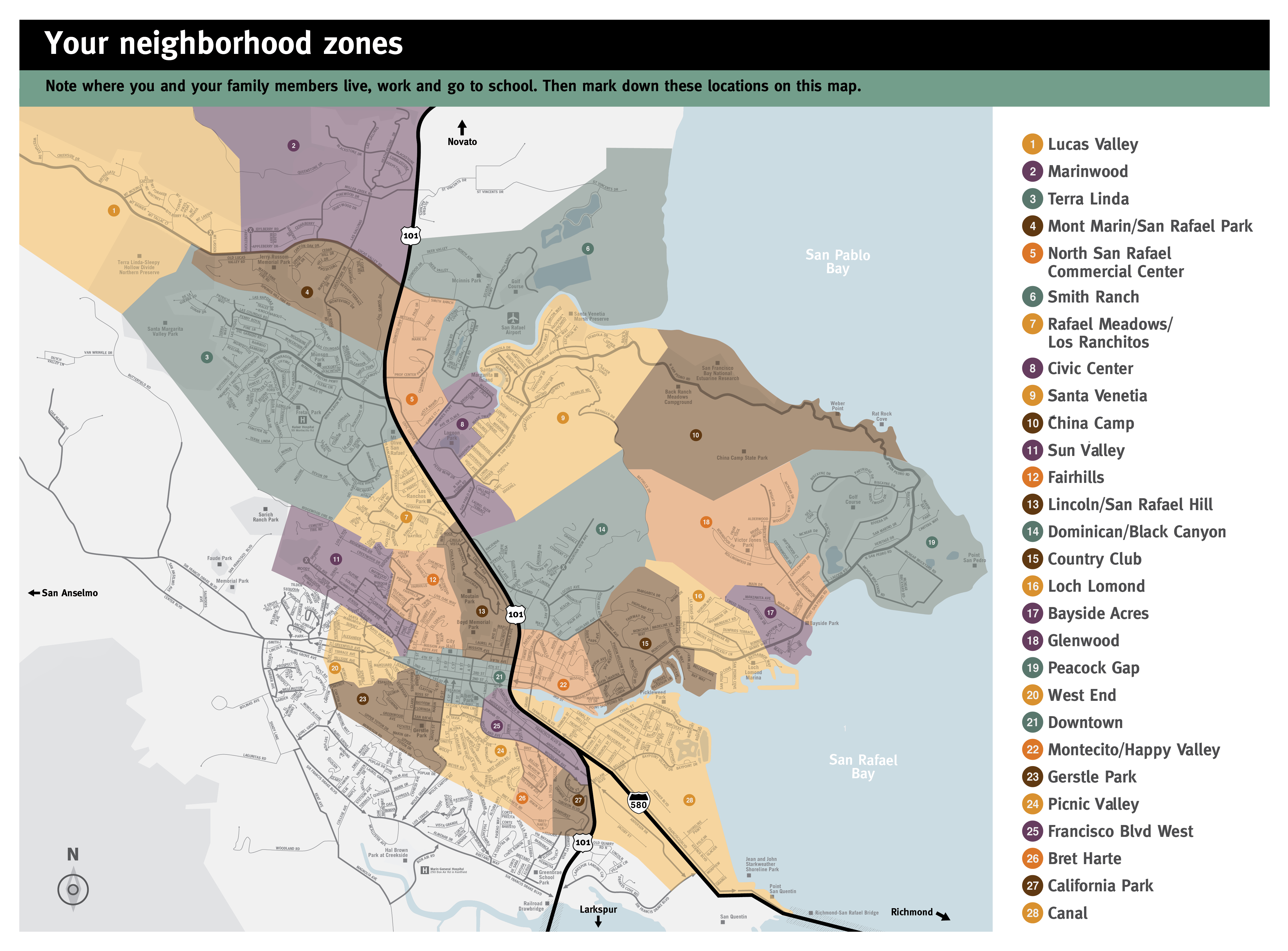
Each area included an area-wide zone map (below) that provided all the zones. That way people could indicate the zone locations of schools, work, and homes of family and friends before any emergency occurs.
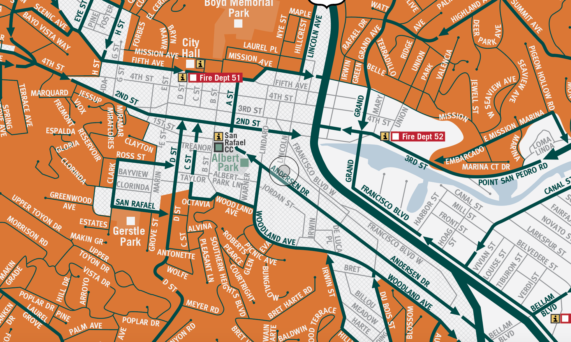
Brochure for Laguna Beach showing fire zones produced as part of FireClear's Visual standards for public-facing rick-literacy maps.

Several brochures for the City of Laguna Beach, Orange County,  showing fire zones produced as part of FireClear's Visual standards for public-facing rick-literacy maps.

Marin County

FireClear is funded by fire agencies, cities, and towns, and a grant from Cal Fire.  Some communities may opt to mail printed copies of these maps to residents with funding support from Marin Wildfire Prevention Authority.

A parcel tax measure was on the ballot for Marin Wildfire Prevention Authority voters in Marin County on March 3, 2020 and it passed. The vote supported authorizing the district to levy a parcel tax of $75 per multifamily unit for 10 years to fund wildfire prevention and preparedness efforts.

Disclaimer: Tsunami information and inundation area is reviewed and revised regularly by CalOES and CGS. The maps below do not reflect the most recent and updated changes. Please do not refer to these maps in an emergency situation. Refer to your local emergency management department in your city for updates.

Close-up of detail for San Rafael, Marin County, produced as part of FireClear's Visual standards for public-facing rick-literacy maps.

Mock-up of a 2-sided poster being held by a women for the City of Novato, Marin County, produced as part of FireClear's Visual standards for public-facing rick-literacy maps.

Full area risk map for the City of San Rafael, Marin County, produced as part of FireClear's Visual standards for public-facing rick-literacy maps.

Full area zone map for the City of San Rafael, Marin County, produced as part of FireClear's Visual standards for public-facing rick-literacy maps.

Full area risk map for the City of Kentfield, Marin County, produced as part of FireClear's Visual standards for public-facing rick-literacy maps.

Full area zone map for the City of Kentfield, Marin County, produced as part of FireClear's Visual standards for public-facing rick-literacy maps.

Layout of a 3-panel Spanish-edition brochure for the City of Irvine, Orange County, providing residents with preparedness information.

Layout of a 3-panel Spanish-edition brochure for the City of Irvine, Orange County, providing residents with preparedness information.
Close-up of an individual zone flyer layout for the San Marin area, Novato, produced as part of FireClear's Visual standards for public-facing rick-literacy maps.

Sacramento County

In 2022, Sacramento County geared up to produce a massive overhaul of public-facing wildfire maps, including a bandana with a working QR code for 31 zones and seven cities in the county.

Sacramento County map showing Fire Hazard Severity Zones, Fire Protection Responsibly Areas, and Light Rail Transportation.
Set of six letter sized flyers showing individual zone maps and information for Sacramento County
Close-up of individual zone with transportation information
Flat image of the county zone map used for the bandana.
Example of Sacramento printing their map on a bandana worn by a woman wearing it around her neck.